Àʪ˙’’∆¨ Àʪ˙’’∆¨ |
|
À’÷ðΩº¶∫˛ ‘ª˙≤‰≈ƒ
∆¿¬€: 0
øµÃ© ±
|
|


|
|
|
√ˆΩ≠…œµƒπ§≥Ã
| √ˆΩ≠…œµƒπ§≥à |
| √Ë ˆ: |
Æ∂˛°¢√ˆΩ≠…œµƒπ§≥Ã
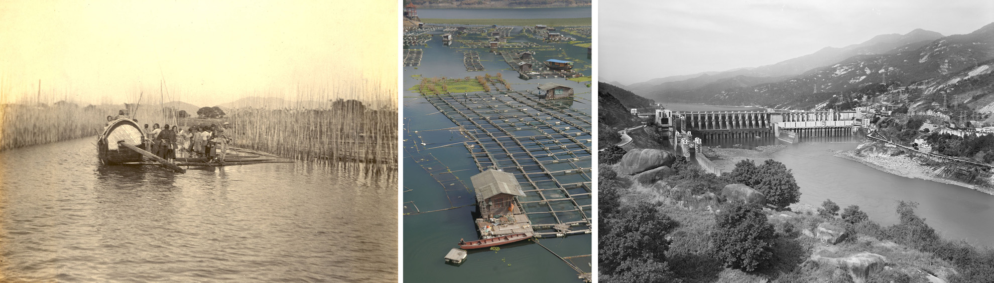
√ˆΩ≠¡˜”ÚΩµÀÆ∑·≈Ê£¨‘¥∂ᘺ±£¨ÀÆ¡ø”Ϊ∆∫”¡˜”ÚµƒÀÆ¡øœýΩ¸£¨∆Ωæ˘√ø»˝ƒÍæÕª·∑¢…˙“ª¥Œ≥¨√ø√Î2ÕÚ¡¢∑Ω√◊µƒΩœ¥Û∫ÈÀÆ£¨≥£ƒÍ±ÿ–Ϊ§∞∂∑¿∫È°£‘ÁƒÍµƒ√ˆΩ≠ª§∞∂º”πà «¿˚”√∆’Õ®µƒ÷Ò∏Õ≤»ÎÀÆ÷–£¨‘˙≥…÷Ò¿È∞ £¨–Œ≥…ÃÏ»ªµƒ÷Ò’§¿∏°£∂˛ Æ ¿ºÕæ≈ ƃͥ˙£¨ÀÆø⁄¥Û∞”µƒΩ®≥…£¨∏ƒ…∆¡À√ˆΩ≠÷–”Œº§¡˜∫Õœ’Ã≤µƒ∫Ω‘À◊¥øˆ£¨¥ŸΩ¯¡À√ˆΩ≠…œ”ŒµƒÀÆ≤˙—¯÷≥£¨Œ™√ˆΩ≠œ¬”Œµƒ∏£÷ðøπ∫È∑¿¿‘÷π©¡À”–¡¶µƒ±£’œ°£
◊Û£¨1920s,£®—«∂´”°ª≠ºØ / ”∞“◊ ±¥˙ ’≤ÿ£©
÷–£¨2009£¨£®Ωπ∫Ϫ‘…„ / ∫£∑Á≥ˆ∞Ê…Á£©
”“£¨2010£¨£®»Óœ˛È≈…„ / ”∞“◊ ±¥˙£©
12. Infrastructures on Minjiang River
The Minjiang River area has plenty of precipitation, which in volume is close to that of the Yellow River basin. But Minjiang is much shorter in length and water currents run rapidly. Every three years on average a big flood would occur, with the water running at more than 20,000 cubic meters per second. Efforts must be made constantly, throughout the year, to consolidate the river bank against flooding. In the early years, the method was to force plant bamboo sticks in the river bottom. The sticks are then tied up and woven into bamboo fence, forming natural bamboo hedge.
The completion of the Shuikou dam in the 1990s has greatly improved the navigation conditions at the rapids and dangerous shores in the middle reaches of the Minjiang River, facilitated aquatic farming at the upper reaches of the river, and provided a strong support for Fuzhou°Øs flood-combating at the lower reaches of the Minjiang River.
Left: 1920s, East Asian Prints / A collection of Film Easy Times
Center: 2009, photo by Jiao Honghui/Sea Breeze Press
Right: 2010, photo by Ruan Xiaorong/Film Easy Times |
| πÿº¸¥ : |
|
| »’∆⁄: |
11.10.2010 18:51 |
| µ„ª˜: |
4813 |
| œ¬‘ÿ: |
0 |
| ∆¿∑÷: |
0.00 (0 Õ∂∆± ˝) |
| Œƒº˛¥Û–°: |
365.6 KB |
| º”»Î’þ: |
edesigner |
|
|
|